 |
The
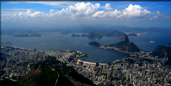
Harbor At Rio de Janeiro
|
It
took the Portuguese explorer, Gon�alo Coelho, three months to
sail from Lisbon, Portugal, to the new world. On August 17th,
1501, he arrived off the coast of what we now call Brazil. He
and his small fleet of three caravels (small, maneuverable sailing
ships) began working their way along the seaboard, mapping the
shoreline of South America. On January 1st, 1502, the ships
reached a break in the seaside that seemed to be the entrance
to an enormous river. The bay they found was spectacularly surrounded
by huge, oddly-shaped mountains that astounded the European
explorers. Taking a cue from the date on which they'd found
this amazing harbor, they named it the "January River," or Rio
de Janeiro.
|
Seven
Quick Facts
|
| Highest
Peak Along Harbor: Corcovado 2,300 feet (700m) |
| Size:
Harbor runs 20 miles (32km) inland. |
| Name:
Means "January River" in Portuguese because of the date
of discovery. |
| Discovered:
By Portuguese explorers on January 1st, 1502. |
| Location:
Brazil, along the Atlantic Coast |
| Formed
By: The interaction of the Serra do Mar mountains
with the ocean. |
| Other:
Mt. Corcovado is capped with a 130-foot (40m) tall
statue named "Christ the Redeemer." |
Geography
The
inlet at Rio de Janeiro isn't actually the beginning of a great
river but a huge balloon-shaped bay that stretches 20 miles
(32km) inland. The harbor is surrounded by giant mountains and
at the entrance of the bay is a lopsided peak of bare granite
standing 1,299 feet (396m) tall that the Portuguese named P�o
de A��car, ("Sugarloaf") because it reminded them of the conical
sugarloaves made on the island of Madeira. The largest mountain
near the harbor rises 2,300 feet (700m) above the water and
is named Corcovado ("The Hunchback") because of its mounded
shape. The bay itself is studded with 130 islands, many of which
are the peaks of smaller hills with their bases covered by the
water.
The
harbor is the result of a great mountain chain (Serra do Mar)
meeting the sea. This set of gneiss and granite stone peaks
runs for 1,500 miles along the coast of South America. It is
the interaction of the softer gneiss rock with that of the harder
granite at the harbor that gives the mountains their spectacular
shapes. Wind, rain and ocean waves erode away the malleable
gneiss where it has no protective layer of tough granite on
top, creating the many steep cliffs and deep valleys.
|
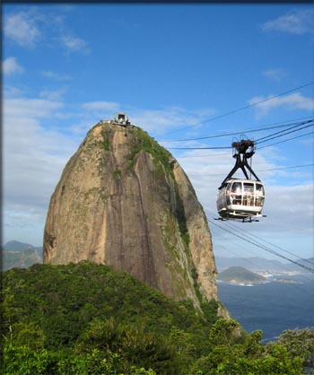
A cable car takes tourists to the top of the Sugarloaf.
(Photo courtesy of Wutzofant licensed under the Creative
Commons Attribution-Share Alike 2.5
Generic license)
|
History
The
Tamoio, one of the native peoples that inhabited the area, called
the place Guanabara which means "arm of the sea," a name that
is still used today. When Europeans tried to settle along the
edge of Guanabara Bay they found it tough going. There was practically
no flat land along the water's edge and those places that were
flat were also swampy. In 1555 five hundred French colonists
built a Fort on one of the Bay's islands they named for their
leader, French Admiral Nicolas Durand de Villegaignon. Five
years later the citadel, Fort Coligny, fell to a siege by Portugal's
navy and the French fled. Today the location, now called The
Isle of Villegaignon, is home to the Brazilian Naval School.
In March
of 1565 the Portuguese got around to founding their own city
at Rio de Janerio which they named Sebasti�o do Rio de Janeiro,
in honor of St. Sebastian. Farming sugarcane was the major industry
in the surrounding region. As it became an important export
the harbor began to become crowded with ships bound for Europe.
Unfortunately, this activity attracted the attention of buccaneers.
In 1711 the French privateer Ren� Duguay-Trouin raided the city
and held the governor for ransom. In the mid-18th century gold
was discovered inland and an influx of European settlers transformed
Rio de Janerio into a boom town. By 1749 the city's population
had expanded to 24,000 and soon it became the capital of the
Portuguese colony. Though sugar and gold declined in importance
as exports in the 19th century, they were replaced by coffee.
Later, cotton and rubber also began to be shipped overseas.
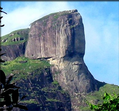
The
gigantic face of Pedra da G�ve
|
The
city remained the capital when Brazil became an independent
kingdom in 1816 and a republic in 1889. In 1960 the capital
was moved to a more central location, the city of Bras�lia.
Rio de Janerio, however, remains the country's second largest
metropolis with a population of over 6 million, and also the
third largest metropolitan area in South America.
Attractions
The
city and the harbor are well known for their scenic beauty.
There are a number of spectacular beaches here including the
famous Copacabana and Ipanema. In the city's South Zone, Pedra
da G�vea, a rock made of granite and gneiss rises 2762 feet
(842m) above the ocean. It has been eroded into the shape of
a human face and can be seen for many miles out to sea. Other
sites that tourists visit here include the top of Sugarloaf
Mountain which is accessible by a cable car system. From the
summit of Sugarloaf, visitors can get a 360-degree view of the
famous harbor.
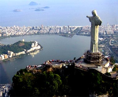
The
statue of Christ the Redeemer stands on top of
the peak of Corcovado. It is 130 feet high and weighs
635 tons. (Photo courtesy of Klaus
licensed under the Creative Commons Attribution-Share
Alike 2.5
Generic license)
|
In the
1850's Catholic priest Pedro Maria Boss suggested building a
large religious monument within the city. Nothing was done immediately
with the idea, but it was not forgotten. In 1921 the Catholic
Circle of Rio organized a crusade to attract donations and collect
signatures in support of building an enormous statue. Several
designs were considered including a cross and a statue of Jesus
with a globe in his hands. Finally, a proposal showing Christ
with his arms outstretched was selected. The statue, composed
of reinforced concrete and faced with soapstone, was erected
at the peak of Corcovado. It stands 130 feet (40m) tall and
the outstretched arms are 98 feet (30m) across. The statue,
completed in 1931 and known as "Christ the Redeemer," weighs
in at 635 tons.Overlooking the harbor, it is accessible by road
and has become a major attraction in the region and a symbol
of the city.
Rio
de Janeiro is also known for its extensive Carnival celebration
in the spring just before the sober religious period of Lent.
Parades featuring music and dancers wearing colorful costumes
occur in many sections of the city. One of the most popular
celebrations is Cord�o do Bola Preta which is held in
the center of Rio de Janeiro and has been attended by as many
as 500,000 people in just a single day.
There
are few people that come to this place that do not appreciate
its natural beauty. The harbor has been called one of the Seven
Wonders of the Natural World. In 1932 when Charles Darwin,
the great naturalist, visited he wrote that the location seemed
almost unreal, like some kind of immense theatrical stage. "Every
form, every shade, so completely surpasses in magnificence all
that the European has ever beheld in his own country, that he
knows not how to express his feelings. The general effect frequently
recalled to my mind the gayest scenery of the Opera-house or
the great theatres."
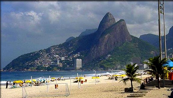
The
famous Ipanema Beach. In the distance the hills are
known as The Two Brothers.
(Photo courtesy of Chmouel licensed under the Creative
Commons Attribution-Share Alike 3.0
Generic license)
|

Copyright
2012 Lee Krystek. All Rights Reserved.