When people think
of the Netherlands two things often come to mind: Tulips and
windmills. Both of these have been symbols of this European
country for centuries. The tulip was introduced from Asia
in the 17th century and has been a source of income for Dutch
farmers ever since. The windmills date from the 1400's and
though they are picturesque, they are actually symbols of
a serious life and death struggle that has raged in the Netherlands
for years: The Dutch people and their land against the sea.
The most recent
of these battles took place in the 20th century when the Dutch
engaged in two massive projects to enlarge and secure their
land against the ocean. The Zuiderzee Works and the Delta
Works took most of the century to complete and together are
considered one of the Seven Wonders of the Modern World.
Polders
The Netherlands
is one of the most low-lying countries in the world. Today
about a quarter of the land area is actually below sea level.
Because of this when a large storm raises the water level
along the coast much of the country is subject to heavy flooding.
In the first century A.D. people began building artificial
hills, called terps, and locating their villages and
towns on top of them so that when floods came their homes
would be safe. After a while it occurred to the people that
if they connected the terps together with long walls, called
dikes, they could keep the water out of their farmlands also.
Eventually the Dutch started eyeing areas that had been unusable
because they were flood zones or were underwater like marshes
and lakes. Dikes were built around these and they were given
the name polders. For a polder to be made dry enough
for framing or building they had to be drained of water. The
earliest pumps were connected to windmills and driven by the
wind. As more and more land was added to the Netherlands through
polders more and more windmills were needed. Soon the Netherlands
became known as the land of windmills.
|
Seven
Quick Facts
|
| Size:
Created 895 square miles of land. (2318 square km) |
| Length:
Afsluitdijk dam - 20 miles (32 km) |
| Cost:
Afsluitdijk $710 million, Delta Works $7 billion |
| Started:
Zuiderzee - 1918, Delta - 1950. |
| Completed:
Zuiderzee - 1967, Delta - 1997 |
| Location:
Netherlands, Europe. |
| Other:
Turned the Zuiderzee from a bay into a lake. |
Taming the Zuiderzee
One of most notable
features of the Netherlands was the Zuiderzee. The name meant
"Southern Sea" in Dutch, but it was actually a shallow bay
of the North Sea that ran 60 miles (100km) inland and was
about 30 miles (50km) wide. Despite its great size covering
almost 2000 square miles it was only about 15 feet deep.
While the Zuiderzee
was a resource for fishing and allowed access for trade, it
could become dangerous whenever one of the frequent North
Sea storms would push water through the bay's inlet. Dikes
would fail and the resulting floods would kill hundreds or
even thousands of people. In 1421 a seawall on the Zuiderzee
dike broke during a storm and flooded 72 villages killing
about 10,000 people.
In the 17th century
the first plans to address this problem were drawn up. It
wasn't until the 19th century, however, that the technology
to actually do the job was developed. Cornelis Lely, a Dutch
civil engineer, came up with a plan that proposed building
a long dam that would close off the Zuiderzee and turn it
into a lake. The plan also included building four polders
in the lake that would be drained and used mainly for agriculture.
Lely became Minister
of Transport and Public Works in 1913 and tried to push his
plan forward. Not everybody agreed with his ideas, however.
Fishermen along the Zuiderzee were concerned that they would
lose their livelihood. Others were worried that such a project
might create higher water levels at other places along the
coast. The government was also alarmed about the enormous
price tag of the project.
In 1916 during
a winter storm, however, several dikes gave way along the
Zuiderzee and the result was more damaging floods. After this
disaster Lely's bold plan gained much public support. On June
14, 1918 the Zuiderzee Act was passed and the project was
officially started. Its goals were to protect the region against
floods from the North Sea, increase the country's food supply
by creating polders that could be turned into farmland and
use what remained of the Zuiderzee to improve water management.
|

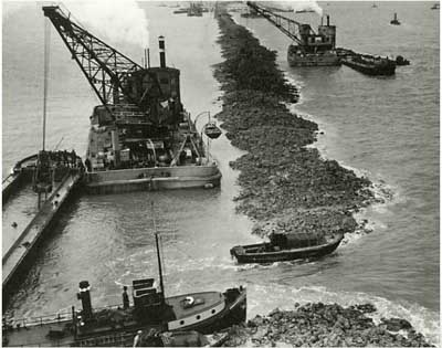
Construction
on the Afsluitdijk in 1931
|
The Afsluitdijk
The first step
in the plan was to enclose the Zuiderzee by building a 20
mile long dam across the bay. Something like this had never
been done before, so the Dutch engineers made the wise decision
to start by building a much shorter dam out to the island
of Wieringen which would form the first part of the enclosure
of the bay. The experience gained in the exercise was valuable
when the longer dam, the Afsluitdijk, was built from the other
side of Wieringen across the bay to the village of Zurich
in 1927.
The engineers found
that a type of material called till (or boulder clay)
made an excellent base for the dam. As the name suggests it
is a mixture of small boulders and clay that was deposited
during the Glacial Period. Fortunately it was readily available
as it could be obtained by simply dredging it up from the
bottom of the Zuiderzee. The till was loaded into ships which
hauled it out to the mouth of the bay and dropped it onto
two parallel lines along what would be the course of the dam.
The space between the two rows of till was filled with regular
sand, and then a layer of till was placed on top. To complete
the base of the dam a coating of basalt rock and willow branches
was laid down. The dam's design called for it to rise 25 feet
above sea level, so another layer of sand was placed to top
of that, which was covered with another deposit of till. The
surface was then planted with grass to help guard against
erosion. The project proceeded faster than planned and was
two years ahead of schedule when on May 28, 1932 the last
connection to the sea was closed that the Zuiderzee became
a lake named Ijsselmeer. Then dam took another year
to fully complete as a road was built along the top and 25
sluices were constructed to allow excess water in the lake
to be discharged to the sea. Two sets of locks were also created
to allow ships to move in and out of the Ijsselmeer to the
ocean. It is estimated the dam cost the equivalent of $710
million in 2004 United States dollars.
Making Land
Even before the
Afsluitdijk was complete, the Dutch started working on the
first of the polders, the Wieringermeer. It's dikes
were completed in 1929 and by 1930 it had been pumped dry,
not by windmills, but by one modern diesel powered pumping
station and one electrically powered pumping station. Both
used large Archimedes screw type pumps to move the water.
Additional work took another four years before the land could
be used for agriculture and construction. The polder added
a total of 75 square miles of area to the country.
The second polder,
the Noordoostpolder, was started in 1936 and draining
it wasn't finished until 1942. The area turned out to be a
good resource for the Dutch Underground resistance in World
War II as it provided almost 230 square miles of undeveloped
land to hide from the Nazi occupation force.
World War II also
brought some setbacks to the project, however. In April 1945,
the retreating German forces blew up the dike of the Wieringermeer,
flooding the land again. Fortunately the Dutch managed to
reclaim the polder by the end of the year, though much of
the infrastructure was destroyed and had to be rebuilt.
In 1950 work on
the the Oostelijk Flevoland, the third polder, was
started and by 1957 it had added 208 square miles of territory
to the Netherlands. Two years later work on the fourth polder,
Zuidelijk Flevoland, was started and finished in 1967.
The Dutch considered
building a fifth polder in the Ijsselmeer, but after several
false starts, it was never completed. Even so the territory
created by the project totaled over 895 square miles.
The Delta Works
The Delta Works
were a series of construction projects started in 1950 designed
to limit flooding. Just south of the Netherlands city of Rotterdam
the Rhine, Meuse and Scheldt rivers meet the North Sea. This
estuary area was extremely low lying and had been subject
to heavy floods for centuries. Shortly after the completion
of the Afsluitdijk, the Dutch decided they could limit the
damage to this area by using dams to effectively shorten the
coastline. No work was started until the 1950's however.
|

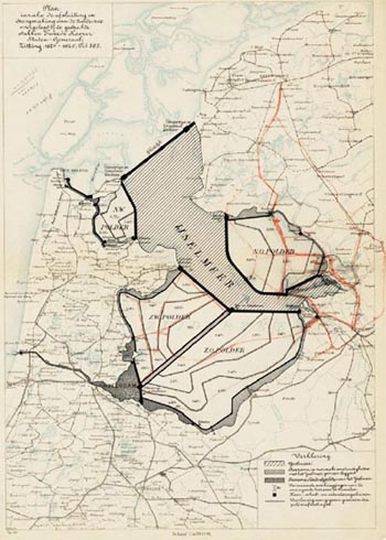
The
Zuiderzee plan drawn up by Lely in 1891.
|
A major flood in
the region during January 1953 killed more than 1,800 people
when a storm surge caused 89 dikes to fail. Over 72,000 residents
had to be evacuated and 10,000 houses and buildings were destroyed.
Repair and reconstruction cost nearly a billion dollars. This
prompted the government move forward with the project as quickly
as it could. Originally the plan called for estuaries Oosterschelde,
Haringvliet and Grevelingen to be dammed and turned into lakes,
just like the Ijsselmeer. Because of environmental concerns,
however, it was decided to protect the Oosterschelde from
storm surges by a barrier instead. The storm surge barrier
is a series of massive values that are normally open so that
water can move in and out of the estuary. This helps preserve
the natural environment. However the valves can be closed
to create a dam during a storm so no high water enters the
area. Another storm surge barrier was also built to protect
the river Nieuwe Waterweg when raising the existing levees
along the waterway proved too difficult.
Though officially
completed in 1997 at the cost of $7 billion, the Netherlands
continues to add infrastructure to the Delta works as needed.
It is estimated that it will continue to need construction
to protect the area against the rising water levels caused
by global warming.

Copyright 2011 Lee Krystek.
All Rights Reserved.